Sender de Puig Castellar
We start the route by leaving the town along the road that leads to Granera, and take the path towards the Castell de Sant Miquel, following the GR 177 markers. After crossing a bridge, we arrive at the castle’s car park, and here we will find a sign for the Puigcastellar route. Following the sign, we will arrive at a crossroads. To path to the left leads to the Castellterçol Castle, the path to the right leads to the Font del Prat Nou (1.4km, there is a picnic area there with tables). We will carry straight on, however, until we arrive at another fork in the path. Here, the path to the left would take us to La Poua de Can Revitllat (2.88km away), the right path leads to the Turó de Rosanes and in the middle is the Ricard path. We continue along the path leading to Ricard and carry on in the same direction to
Sant Julià d’Úixols, with a series of steep climbs which, bit by bit, help us to gain altitude until we arrive at the chapel.
Sant Julià d’Úixols (55 min / 3.3km) was a rural parish under the authority of Castellterçol. The pre- Romanesque chapel was built at a height of 900m and is a popular destination for walkers. We can either return the way we came or continue on ahead.
Below the chapel, we arrive at a crossroads where we will take the left path towards L’Era de les Cases and Sant Quirze Safaja. After 20 minutes we arrive at a fork in the path, we continue to the left, following the GR 177. L’Era de les Cases is one of the many historic masias (traditional Catalan farmhouses) that we can find in Castellterçol. From here, we will take a narrow track to the left (behind the house) which is indicated with lilac markers. We head up the track, enjoying the panoramic views of the Moianès region and the Pyrenees. Shortly after, we will head down towards the Collet de Puigcastellar, and then further on we will see some of the remains of the walls of the Puigcastellar masia still standing. We will also find the remains of an Iberian village, located just above the walls of the house.
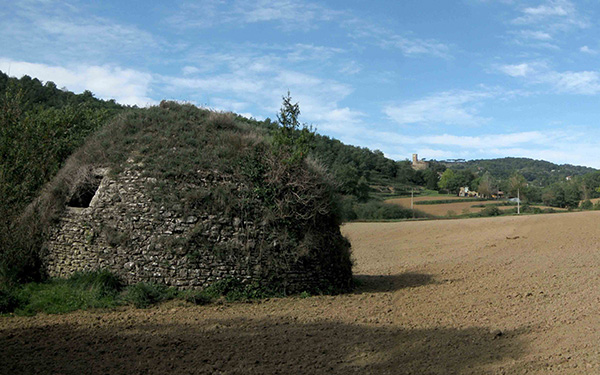
To the right of the ruins, still following the lilac markers, we will carry on along the track, which gradually becomes wider. We arrive at a crossroads where we take the path leading to the left, following the lilac trail markers. A little further ahead, about 300m or so, we will find ourselves atop a small hill, to the right of which there is a small path which we take, leaving the main path behind. A few metres further on, we arrive at a wider path which we take to the left towards the Masia de La Noguera, another of the area’s historic masias. Heading past the house, we carry on along the path which leads us to the road. We turn right along the road towards Castellterçol and as soon as we have crossed the stream there is a narrow track rising slightly to the left. We take the track until we arrive at a fork which to the right would bring us back to the road. We take the left path, however, along a wider path that starts to head downhill. We then arrive at the Poua de Can Revitllat, which is one of the most well-known ice wells, located in the fields near the old Castellterçol castle. Without a doubt it is the best conserved and attractive of the ice wells. What’s more, the well is open and the surrounding area has been cleared so that the structure can be fully appreciated. From the lower part you can see the whole structure.
We continue along the path which heads uphill, arriving at the Casuc, a masia with a pretty pond. We continue along Carrer St. Antoni until Plaça Miquel Cospinera, and then head along Passeig de la Riba to return to the town.
+INFO
Longitud: 10 Km. Desnivell: 200m. Durada: 3h. 35m. Dificultat: Mitjana


